Section 3 Historical fire regimes
Ponderosa pine forests, like those that cover the Chuska Mountains and Defiance Plateau, are highly adapted to frequent low-severity fires36. Recurrent surface fires characterize this fire regime, which we define by the frequency, severity, extent, and seasonality of fires over long time periods and the interactions of fire with climate, vegetation, and human activities37. Across the western US, active fire regimes are all but extinct, having rapidly and nearly-synchronously ended in the late 1800s. Multiple factors contributed to the decline of frequent fire activity and the current era of fire exclusion. After 1870 the railroad arrived to many areas, ushering in intensive livestock grazing and industrial-scale logging. In some places, removals and population loses among Native American tribes may have been a factor. After 1910, the Federal Government enforced active fire suppression efforts that largely continue38.
Understanding historical fire regimes on particular landscapes is of value in the face of future climate change. Because ponderosa pine and other forest types of the Southwest are highly adapted to fire, recurrent burning imparts resilience to extreme events. Frequent fire regulates fuel loads and forest structure, and affects recruitment patterns. Recurrent surface fires create a landscape mosaic of burned and unburned patches that provide diversity in vegetation and wildlife habitat. The patchwork also breaks up the continuity of surface fuels, limiting the spread of subsequent fires, and reducing the probability of high-severity fires.
Reconstructions of historical fire regimes act as a guide for managing fire on a landscape. They provide context to forest flammability and the extent to and conditions in which fires have burned in the past. Reconstructions also provide a unique window into historical human land-use patterns, and how these activities may have altered disturbance regimes. Knowing when and where fire regimes ended can aid in prioritizing certain areas for restoration, as those with the greatest departure from historical range of variability may be in most need of restoration39.
Across the western US, the collapse of frequent surface fire regimes is most often attributable to settlement by Euro-Americans, and the land-use changes they initiated. The Navajo Nation was never settled by Euro-Americans. It has been the homeland of the Diné for many centuries, and apart from a traumatic period of forced removal in the 1860s, the landscape has remained under the exclusive control and use of Diné. The fire history of the Navajo forest, therefore, tells a uniquely Navajo story.
We have reconstructed historical fire regimes in the Navajo forest using tree-ring samples from fire-scarred trees (Figure 3.1). Surface fires that burn through fine fuels along the forest floor sometimes wound trees but do not kill them. The fires can leave a permanent scar behind in the wood, which can be identified and precisely dated to the year and sometimes season of the fire via dendrochronological techniques40,41.
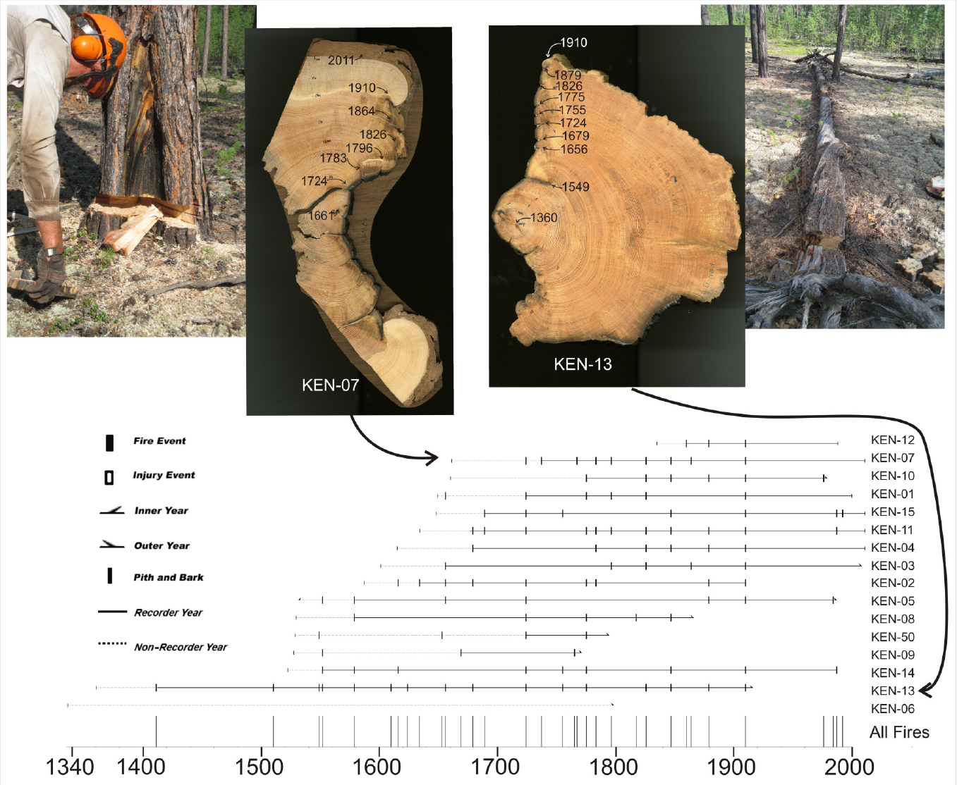
Figure 3.1: Reconstruction of historical fires from tree rings in Siberia. Partial cross-sections of trees, stumps, and logs contain preserved fire scars that can be precisely dated (top). The fire-scar dates are combined by tree (horizontal lines at bottom) for each site to generate a master chronology of fire activity (tick marks at bottom), providing long-term records of fire regimes. (Credit: Chris Guiterman, unpublished).
Our collections of Navajo fire-scarred trees cover much of the Chuska Mountains and Defiance Plateau forests (Figure 3.2). A separate collection was made in the Buffalo Pass area near Lukachukai42 with similar results to those presented below. In this section, we analyze collections made by Savage & Swetnam (1990)43 and Guiterman (2016)44. We separated our collections by landscape to contrast the effects of different historical land-use intensities between the Chuska Mountains and Defiance Plateau.1
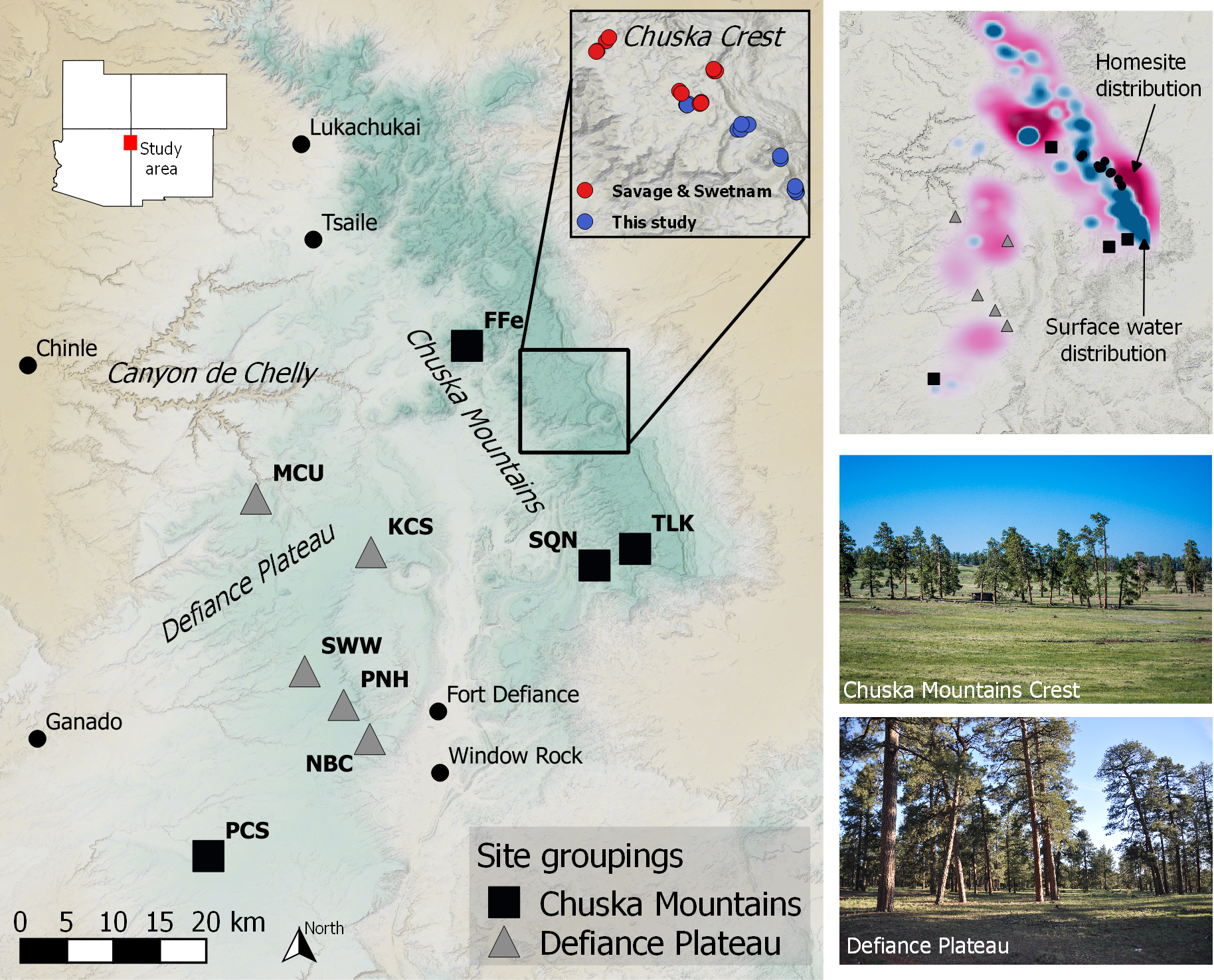
Figure 3.2: Distribution of fire-history sample sites in Navajo forests. On the left map, the inset on the upper left shows the study area location in the Four Corner States; at the upper right is the distribution of trees collected by Savage and Swetnam (1990) with our additional sampled trees. The upper-right map shows the density of present-day homesites and lakes in the study area, as an indication of historical concentrations of land use. At bottom right are photos of the Chuska Crest (credit Dan Ferguson) and the Defiance Plateau (credit Chris Guiterman).
Our fire history reconstruction is based on 204 fire-scarred trees sampled at 14 sites, and includes 1,560 precisely-dated fire scars. The reconstruction shows us that fires were once very common on the landscape, burned extensive areas (like the entire Chuska Crest) during particular drought years, and mostly occurred in spring to early summer. The tree-ring fire scars document frequent surface fire activity back to at least 1532. We cut off our reconstruction at 1532 because fire-scarred material is often consumed by fire over time, limiting our confidence to the scale and frequency of fire prior to the early date, though we had found earlier fire scars. The last widespread fire in our record was in 1886, making for a 354-year reconstruction which is quite long for the Southwest region.
3.2 Why did fires stop?
Across the western US, fire regimes collapsed as hundreds of thousands of sheep and cattle were unleashed into nearly every mountain range. In the Southwest, these introductions usually coincided with the arrival of the railroad after 1870, which provided easy access to new terrain and the economic incentives of eastern markets. Livestock contributed to the collapse of frequent surface fires by consuming the fine herbaceous fuels (grasses) that fires had consumed46. Similar processes ended fire activity in Navajo forests, but an interesting and uniquely Navajo pattern is present as well (Figure 3.3).
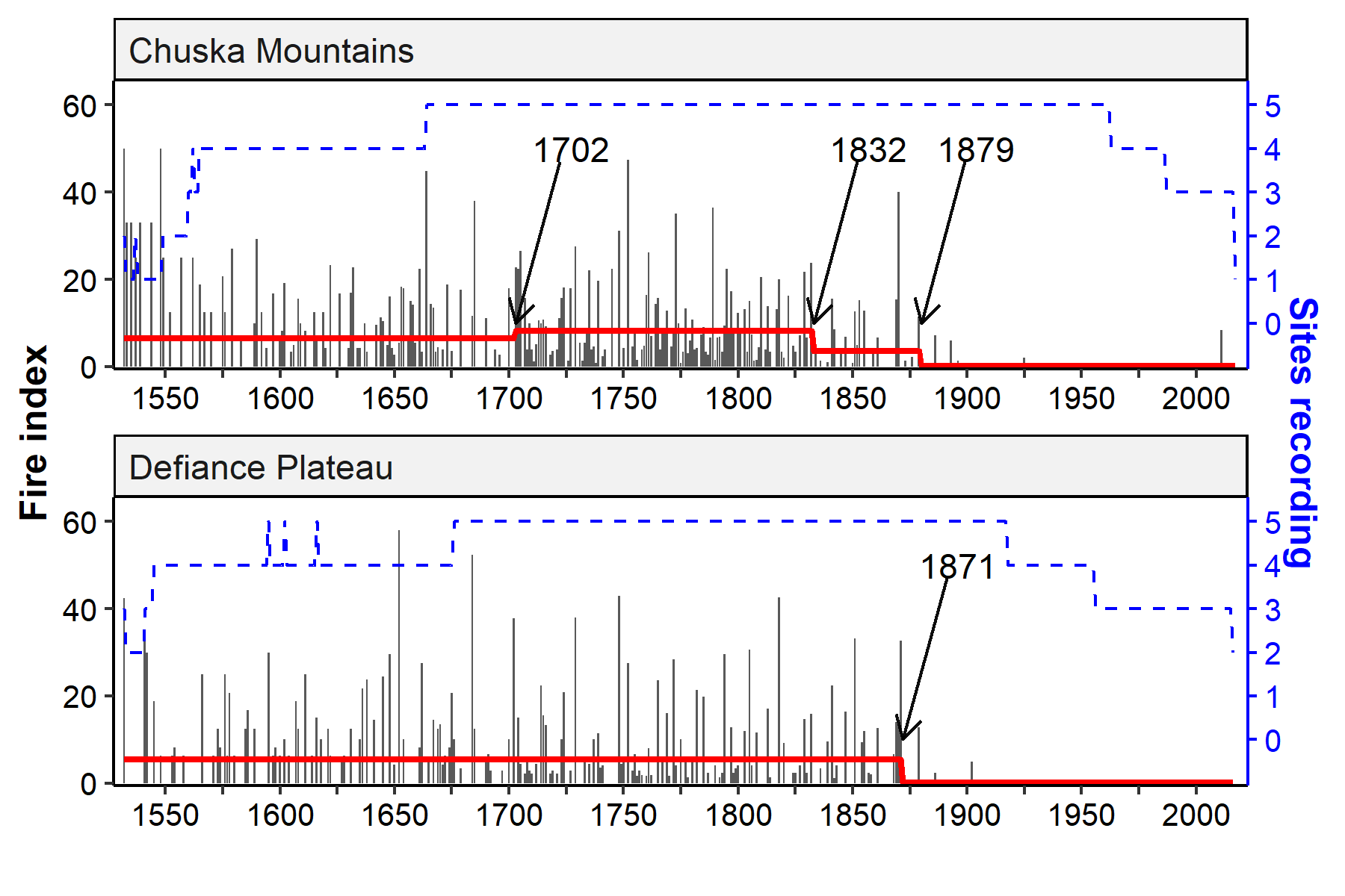
Figure 3.3: Historical fire activity in the Chuska Mountains and Defiance Plateau. Arrows indicate changes in the average fire extent (quantified as fire index - the percent of trees and sites recording fire).
Diné had adopted pastoralism of sheep and goats long before the arrival of the railroad to the area in 188047. Unlike Euro-American livestock grazing practices, pastoralism by Navajos was concentrated in certain areas where resources like water and grass were plentiful. Many families drove sheep and goats on long-range migrations every summer to the uplands on the Chuska Crest48. It was a daily practice to bring animals from homesite corrals to water sources, graze, and back to the corral. This makes for localized impacts of grazing as it concerns fire activity; fires could still burn in areas where people did not often take their animals and grazing pressure was low. The Navajo fire history reflects these land-use patterns, with different timing and extent to the decline in historical fire between the Chuska Mountains and the Defiance Plateau.
In the Chuska Mountains, fire activity shows an early decline after 1832, with markedly fewer fire events and longer fire return intervals until 1879. These changes did not happen on the Defiance Plateau. The Chuska Mountains were, and largely remain, the main destination for summer livestock grazing. The Chuskas have more available surface water and a higher density of homesites than the Defiance Plateau (Figure 3.2). In the early to mid-1800s, pastoralism among the Diné grew at an accelerated rate, with more people adopting it and herd sizes growing steadily to total roughly 500,000 animals in the late-1850s49,50. This increase in grazing animals affected fires, so that after 1832 fewer fires burned on the landscape. The Defiance Plateau, by contrast,with its less available water resources was likely much less used for historical grazing, and widespread fires continued to burn there until 1871.
The end of historical fire regimes on the Navajo Nation came at a time of population growth and change on the landscape. By the mid-1870s the Diné and their livestock herds were recovering from the forced exile to Bosque Redondo. As survivors returned after 1868 they were provisioned with livestock by the US Government, and provisions continued for another decade. By 1880, the population of grazing animals grew exponentially to over a million49. The arrival of the railroad to the area also ushered in a new era of trading posts across the landscape, bringing new products for trade and access to distant markets for famed Navajo wool and rugs. Herd sizes continued to grow rapidly, and land-use impacts spread throughout the forest area. After 1880 fires were no longer extensive or frequent anywhere on the landscape (Figure 3.3). And, as noted, the last widespread fire was recorded in 1886.
These patterns of fire activity in the Chuska Mountains is unique to the Navajo forests. No where else is it documented that fire activity was sustained alongside livestock grazing for so long. Fires in the Chuska Mountains continued for nearly 50 years at a time of growing pastoralism.
Another pattern worth noting is the increase in fire activity in the Chuska Mountains after 1700. It is widely accepted that Diné began to settle the present-day Navajo Nation in the late-1600s, and continued to come during the 1700s51,52. Prior to that, the landscape was likely unpopulated for approximately 300 years since the Puebloan depopulation of the Colorado Plateau. The increase in fire activity on the Chuska Crest after 1702 could likely be the result of this migration and intensified use of the land by people. Similar patterns of increased fire activity associated with historical Native American land-use have been found elsewhere, including northern New Mexico and California38,53. That this pattern was present for the Chuska Mountains and not the Defiance Plateau lends further support for different land-use intensities between the two landscapes, and different human-fire interactions.
3.3 How was fire activity related to climate?
Because fires require dry fuel to burn, most widespread fires in Navajo forests occurred during drought years (Figure 3.4). Here, we consider drought as years with below-average summer PDSI, or Palmer Drought Severity Index, as reconstructed from independent tree ring collections54. PDSI reflects summer soil moisture, which in this region is most highly influenced by snowpack from prior winter precipitation55. This means that dry winters lead to extensive spring and summer fires in Navajo forests. Indeed, the strongest fire-climate relationship we found was for years in which more than one of our sites recorded widespread fire (i.e., synchronous fire years). Significant drought conditions in these synchronous-fire years helped to prime the landscape for extensive fire activity. Smaller fires - those that burned only a single site - were common, but were not strongly associated with drought.
![Historical fire-climate relationships in Navajo forests. (A) Temporal variation in Palmer Drought Severity Index [PDSI] with single-site and synchronous [multiple site] fire years superimposed on the timeseries. (B) Superposed Epoch Analysis [SEA] of the fire years. In SEA, the year of fire is the zero-lag year. PDSI is averaged for all fire years as well as the years before and after. The graphs in (B) show that for all widepsread fires and years of synchronous fire, signficant PDSI departures [i.e. drought] are required, as are up to three wet years before a fire. Significance of the PDSI timeseries was evaluated by bootstrapping PDSI. The number of fire years for each SEA is provided as the n value.](Figs/fire-sea.png)
Figure 3.4: Historical fire-climate relationships in Navajo forests. (A) Temporal variation in Palmer Drought Severity Index [PDSI] with single-site and synchronous [multiple site] fire years superimposed on the timeseries. (B) Superposed Epoch Analysis [SEA] of the fire years. In SEA, the year of fire is the zero-lag year. PDSI is averaged for all fire years as well as the years before and after. The graphs in (B) show that for all widepsread fires and years of synchronous fire, signficant PDSI departures [i.e. drought] are required, as are up to three wet years before a fire. Significance of the PDSI timeseries was evaluated by bootstrapping PDSI. The number of fire years for each SEA is provided as the n value.
Critical to historical landscape fires was the continuity and abundance of fuel. Drought cured the fuel and made it ready to burn, but the antecedent wet years shown in Figure 3.4B underscore the requirement for favorable years of growth for grasses and other herbaceous plants required for fire spread. Isolated, single-site fires, antecedent moisture was important one year prior to fire.
This dependence on antecedent moisture to produce continuous and abundant surface fuel for fire activity is one reason why the Navajo forest was susceptible to grazing impacts. After 1832, fire spread was inhibited because of the consumption of grass and the disruption of the surface fuel layer by livestock. These impacts led to the collapse of historical fire regimes after the late 1870s.
3.4 What was the historical fire season?
Tree rings not only record the year of a fire, they can also record the season during which the fire burned. In Figure 3.5, pie charts show the distributions of fire seasonality during the 1532-1886 historical period. Across both landscapes, fire scars were predominately recorded in the dormant season - or the period before tree growth begins in spring. We designate dormant-season fire scars as spring events based on the record of observed fires for the Southwest, which shows that spring (April) fires are far more common than late-fall fires56. Fires occurring in the early-earlywood portion of the ring, right after the onset of radial growth, likely occurred in May. Fires in June tend to be recorded as middle-earlywood fire scars. And finally, July-August fires would be recorded in the latter portion of the tree rings as late-earlywood and September fires as latewood scars. These late-season fires correspond with the monsoon in the Southwest, when fire ignitions are plentiful due to lightning but fire spread is reduced due to soaking rains56,57. The most extensive fires occur during the May-June fore-summer drought56, and historical fire activity was most common between April and late June.
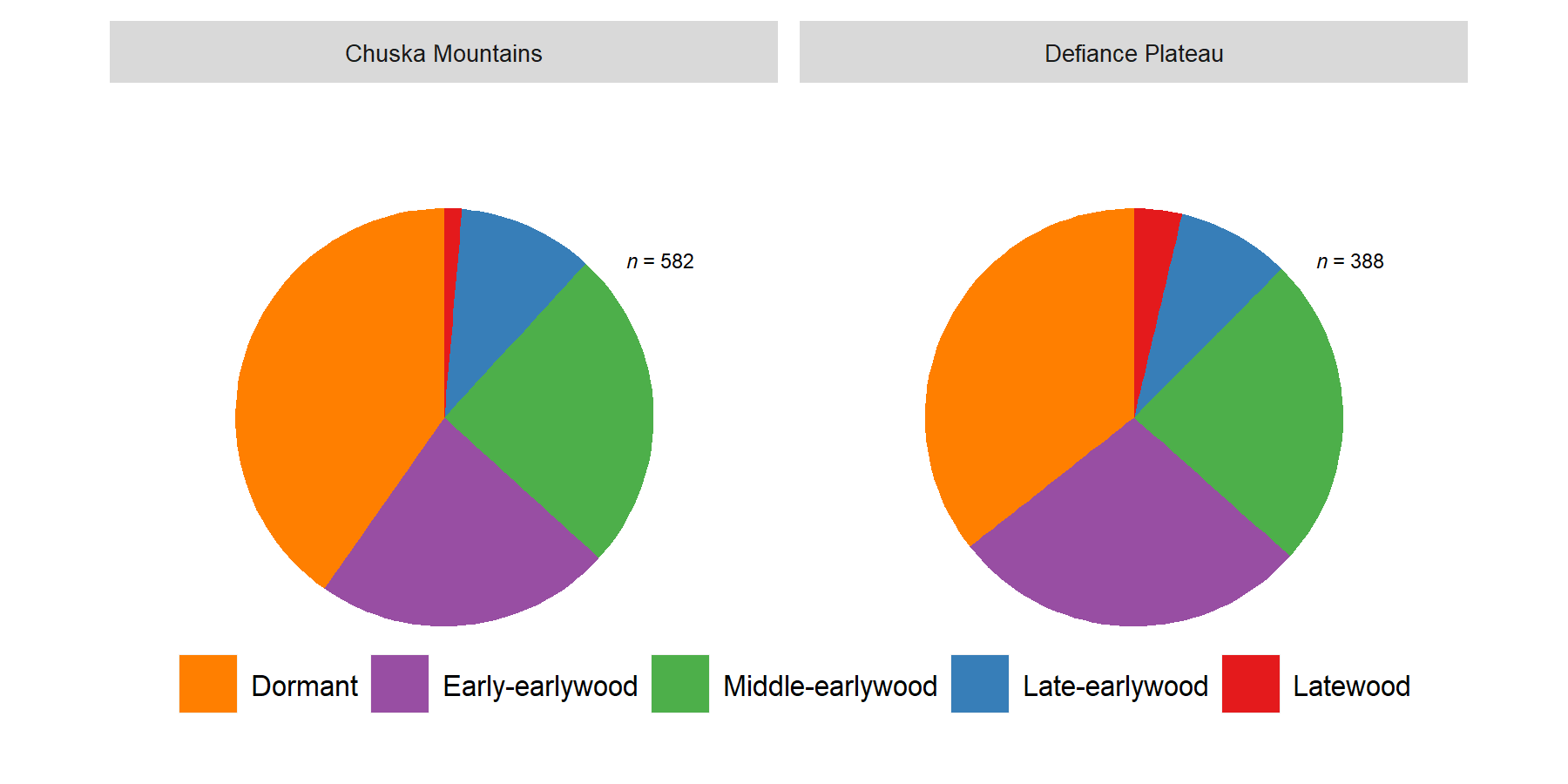
Figure 3.5: Fire-scar seasonality during the 1532-1886 reconstruction period. Seasons correspond to intra-ring positions of fire scars, and correspond to the months April through August (see text). The number of scars in each pie chart is provided by the n values.
3.5 How does historical fire extent compare to modern fires?
Landscape-scale fires occurred many times historically. In 1870, for example, the entire crest of the Chuska Mountains burned (Figure 3.6). Extensive burning was also recorded at Buffalo Pass in 187042, meaning fire burned across more than 35 miles of forested area in a single year, despite grazing pressures. In 1871, the following year, fire spread across the Defiance Plateau. Events such as these were relatively common historically. We found extensive landscape burning in years such as 1684, 1748, and 1818, just to name a few (see Figure 3.3). By contrast, the largest recent fire on record is the 15,000 acre Asaayi Lake Fire that burned for several days in mid-June of 2014. What sets the Asaayi Lake Fire apart from the historical fires are its effects - the Asaayi Lake Fire created large patches of fire-killed trees where it burned at high severity across nearly 1/3 of the burn area. The extensive historical fires were unlikely to have generated patches of high-severity fire at anything close to the same scale. All of the trees that recorded fires in 1870 survived the fire. Modern changes in fire behavior stem from the lack of fire over the last century and longer. Fire deficits increase forest densities and fuel loads, often creating conditions where ladder fuels can create crown fire in forests otherwise adapted only to surface fires36,45. The historical extent of fires underscores a major vulnerability of the modern forest - that under the right conditions it can burn across vast areas in high-severity fire.
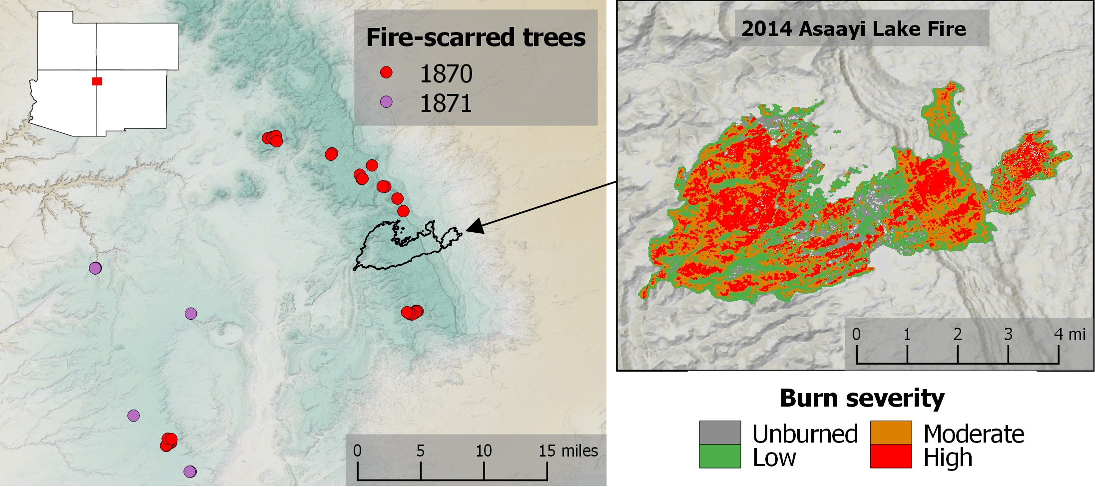
Figure 3.6: Comparison of historical and modern fire extent. Historical fires were recorded across hundreds of thousands of acres, such as in 1870-1871. These particular years were the last time that Navajo forests experienced landscape-scale fire. The 2014 Asaayi Lake Fire was small by contrast, burning 15,000 acres. The effects of the Asaayi Lake Fire, however, were far more dramatic and killed many more mature trees than the extensive surface fires of the 1870s and other historical fire events.
Climate change also presents challenges to forests recovering from extreme fire behavior, like witnessed in the Asaayi Lake Fire. Regeneration of ponderosa pines and other conifers in high-severity burn patches is limited by drought stress, seed dispersal, and competition with resprouting shrubs. Should regeneration fail post-fire, the patches could transition to another vegetation type like Gambel oak shrubfield or grassland28. Some areas of Gambel oak shrubfield in New Mexico have lasted longer than a century and likely represent permanent type conversion to a new vegetative state29.
3.6 What is the current risk for high-severity fire?
Predicting a dynamic process like fire behavior is challenging, as it depends on a suite of conditions. Fuel loading, fire weather, long-term drought conditions, terrain, vegetation type, and suppression efforts all play into how fire will behavior in any given event. Knowing where fire is more or less likely to become severe, with stand-replacing effects, is thus a valuable insight. Recent work examined the various factors that influence the occurrence of high-severity fires over the last several decades, and used that information to predict the likelihood of high-severity fire across the western US58. Results for the Navajo forest area show considerable spatial variability in the probability of high-severity fire under extreme fire weather (Figure 3.7). For this region, 58 found that live vegetation and fire weather were the most important drivers of high-severity fire behavior. Areas of the Navajo forest most at risk for high-severity fires are those in which stand densities are greatest. High stand densities lead to high fuel loads from small trees (ladder fuels). These areas include the northwestern parts of the Defiance Plateau and the Lukachukai area in the northern Chuska Mountains. By contrast, a large area of the Defiance Plateau has relatively low probability for high-severity fire due to generally open stands dominated by large, old, fire-resistant ponderosa pine trees. The map in Figure 3.7 can be used as a general guide to point restoration efforts toward the areas where it is most needed. On-the-ground inspections should be conducted to validate and verify this information, but our general sense of the area supports the patterns found by 58 in Figure 3.7.
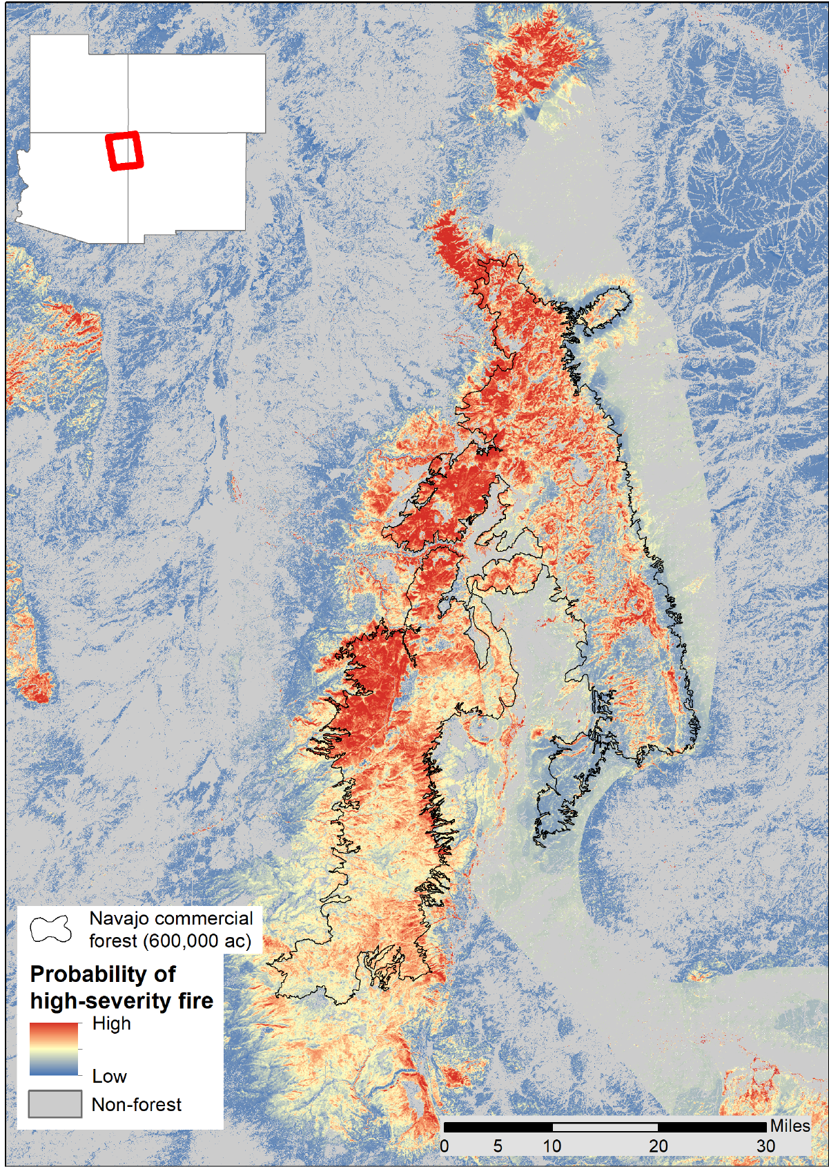
Figure 3.7: Relative probabilities for high-severity fire behavior under extreme fire weather. Vegetation describes most of the variability in potential high-severity fire. Data from Parks et al. (2018).
3.7 Conclusions
Tree-ring reconstructions of historical fire regimes across the Navajo forest underscore the flammability of the landscape. Fires were once common in the Chuska Mountains and Defiance Plateau, with extensive fire events occurring once a decade. Fires had the potential to burn across vast acreages in certain years, often following a dry winter with spring and early summer fires. The reconstructions also document human impacts on fires, whereby the expansion of livestock herds in the 1800s disrupted fire activity and ended the fire regimes. The lack of fire is now over 140 years in some places. A fire deficit of this duration in the forest types of the Navajo Nation represents a significant vulnerability to forest health, human resources, and ecosystem services.
As across most forest types of the American West, the Navajo Nation forests are primed to burn, and calls for restoration toward resilience to wildfire are as pertinent here as anywhere else. The data presented above not only document this need, they can be used to guide restoration activities with place-based information on fire return intervals, fire extent, seasonality, and associations with historical land-use practices and climate.
Climate change will increase the flammability of Navajo forests. Management to return historically frequent, low-severity fire and associated less-dense forest structure would be ecologically beneficial to the ponderosa pine forests of the Navajo Nation. It would provide resilience to the forests in terms of ability to withstand likely increases in future disturbance such as high-severity fire and tree mortality due to drought stress and insect outbreaks.
References
36. Agee, J. K. Fire Ecology of Pacific Northwest Forests. (Island Press, 1993).
37. Whitlock, C., Higuera, P. E., Mcwethy, D. B. & Briles, C. E. Paleoecological Perspectives on Fire Ecology: Revisiting the Fire-Regime Concept. Holocene 6–23 (2010).
38. Swetnam, T. W. et al. Multi-Scale Perspectives of Fire, Climate and Humans in Western North America and the Jemez Mountains, U.S.A. Philosophical Transactions of the Royal Society B 371, 20150168 (2016).
39. Allen, C. D. et al. Ecological restoration of southwestern ponderosa pine ecosystems: a broad perspective. Ecological Applications 12, 1418–1433 (2002).
40. Dieterich, J. & Swetnam, T. Dendrochronology of a fire scarred ponderosa pine. Forest Science 30, 238–247 (1984).
41. Baisan, C. & Swetnam, T. Fire history on a desert mountain range: Rincon Mountain Wilderness, Arizona, USA. Canadian Journal of Forest Research 20, 1559–1569 (1990).
42. Whitehair, L., Fulé, P. Z., Meador, A. S., Azpeleta Tarancón, A. & Kim, Y.-S. Fire regime on a cultural landscape: Navajo Nation. Ecology and Evolution 1–11 (2018). doi:10.1002/ece3.4470
43. Savage, M. & Swetnam, T. Early 19th-century fire decline following sheep pasturing in a Navajo ponderosa pine forest. Ecology 71, 2374–2378 (1990).
44. Guiterman, C. H. Climate and human drivers of forest vulnerability in the US Southwest: Perspectives from dendroecology. 185 (University of Arizona, 2016).
45. Covington, W. W. & Moore, M. M. Southwestern ponderosa pine forest structure: Changes since Euro-American settlement. Journal of Forestry 92, 39–47 (1994).
46. Belsky, A. J. & Blumenthal, D. M. Effects of Livestock Grazing on Stand Dynamics and Soils in Upland Forests of the Interior West. Conservation Biology 11, 315–327 (1997).
47. Weisiger, M. The origins of Navajo pastoralism. Journal of the Southwest 46, 253–282 (2004).
48. Jett, S. Navajo seasonal migration patterns. The Kiva 44, 65–75 (1978).
49. Bailey, G. & Bailey, R. G. A history of the Navajos: The reservation years. (School of American Research Press, 1986).
50. Weisiger, M. Dreaming of sheep in Navajo country. (University of Washington Press, 2009).
51. The Archaeology of Navajo Origins. (University of Utah Press, 1996).
52. Towner, R. H. The Navajo depopulation of Dinetah. Journal of Anthropological Research 64, 511–527 (2008).
53. Taylor, A. H., Trouet, V., Skinner, C. N. & Stephens, S. Socioecological transitions trigger fire regime shifts and modulate fire–climate interactions in the Sierra Nevada, USA, 1600–2015 CE. Proceedings of the National Academy of Sciences 113, 13684–13689 (2016).
54. Cook, E. R. & Krusic, P. J. The North American Drought Atlas. (2004).
55. St. George, S., Meko, D. M. & Cook, E. R. The seasonality of precipitation signals embedded within the North American Drought Atlas. The Holocene 20, 983–988 (2010).
56. Swetnam, T. W. & Betancourt, J. L. Mesoscale disturbance and ecological response to decadal climatic variability in the American Southwest. Journal of Climate 11, 3128–3147 (1998).
57. Margolis, E. Q., Woodhouse, C. A. & Swetnam, T. W. Drought, multi-seasonal climate, and wildfire in northern New Mexico. Climatic Change 142, 433–446 (2017).
28. Savage, M. & Mast, J. N. How resilient are southwestern ponderosa pine forests after crown fires? Canadian Journal of Forest Research 977, 967–977 (2005).
29. Guiterman, C. H., Margolis, E. Q., Allen, C. D., Falk, D. A. & Swetnam, T. W. Long-Term Persistence and Fire Resilience of Oak Shrubfields in Dry Conifer Forests of Northern New Mexico. Ecosystems 21, 943–959 (2018).
58. Parks, S. A. et al. High-severity fire: Evaluating its key drivers and mapping its probability across western US forests. Environmental Research Letters 13, (2018).
We made one exception to the division of sites by landscape, for the site PCS (Pine Canyon South) on the southern Defiance Plateau. In examining the fire history there, we identified multiple periods of human-caused interruptions to fire activity that closely resembled patterns normally found in the Chuska Mountains. The site is close to long-term Navajo settlement areas and clans associated with Jemez and other Pueblo peoples that might have migrated there in the 1680s during the Pueblo Revolt.↩